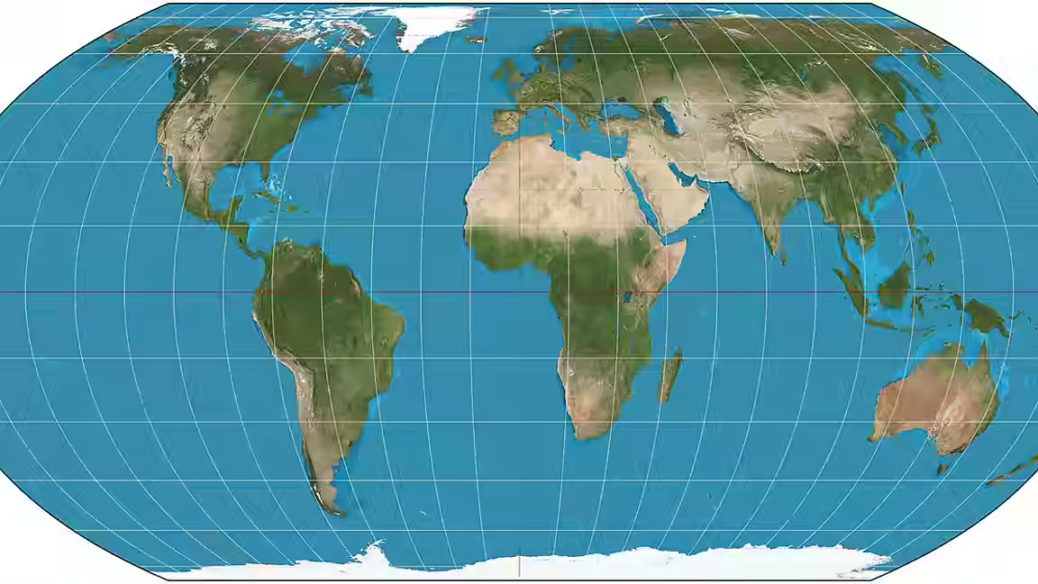
The United Nations General Assembly has voted to support a shift away from the Mercator world map and toward the Equal Earth projection, a move that supporters say will better reflect the size of Africa and other equatorial regions.
On the event date, the assembly backed a Togo-sponsored resolution on cartographic representation. The vote was 164 in favor, one against and six abstentions. The lone no vote came from the United States, whose representative called the measure superfluous. Although the resolution is non-enforceable, it is expected to influence classrooms, digital mapping and other public uses where the Mercator projection has long been dominant.
The outcome gives formal international backing to a campaign that has argued for years that the familiar Mercator map distorts the scale of continents. The resolution language, as quoted in the packet, says disproportionate cartographic representations have had lasting cognitive, educational, cultural, geopolitical and socioeconomic effects, and have helped reduce the perceived size of Africa and other regions in the global imagination.
The map question is not new. The Mercator projection was introduced in 1569 for navigation, and it remains widely used because it preserves shape and direction for sailors, even though it enlarges land near the poles and shrinks land close to the equator. That means Africa appears far smaller than it is, while Greenland and other high-latitude regions seem larger than their actual area would suggest. The packet notes that Africa is in fact 14 times larger than Greenland.
Togo's foreign minister, Robert Dussey, framed the debate as scientific rather than political. France backed the move as well, saying it would abandon the Mercator projection in favor of map representations that better reflect actual surface areas. France also said it would now use the Eckert IV projection, a design close to Equal Earth.
Support for the resolution has been building for some time. The African Union endorsed the #CorrectTheMap campaign in August 2025 and later asked Togo to lead the push. The campaign has used petitions and public advocacy to argue that map design is not neutral, but instead shapes how people understand geography, power and scale. Critics of Mercator have long argued that map choices can subtly reinforce outdated hierarchies by making the global south look physically smaller than it is.
The vote does not force anyone to stop using Mercator overnight. UN resolutions are not binding, and the packet notes that countries and institutions can still choose whichever projection suits their purpose. But the symbolism is important. A UN endorsement can shift curriculum standards, public-sector mapping and the default assumptions built into technology products.
That is why the decision matters beyond cartography. The projection chosen for a map is also the projection chosen for a worldview. For African diplomats and campaigners, the point is not just that Africa is larger than many people realize. It is that a more accurate map can help correct a long-running visual bias in how the continent is presented to the rest of the world.
The practical next step is implementation. Togo said it is planning a meeting in Lomé with UNESCO, the African Union and technology companies such as Google Maps to work through how the resolution should be adopted. The UN vote may not redraw the world overnight, but it gives the Equal Earth campaign something it has long wanted: international legitimacy.